
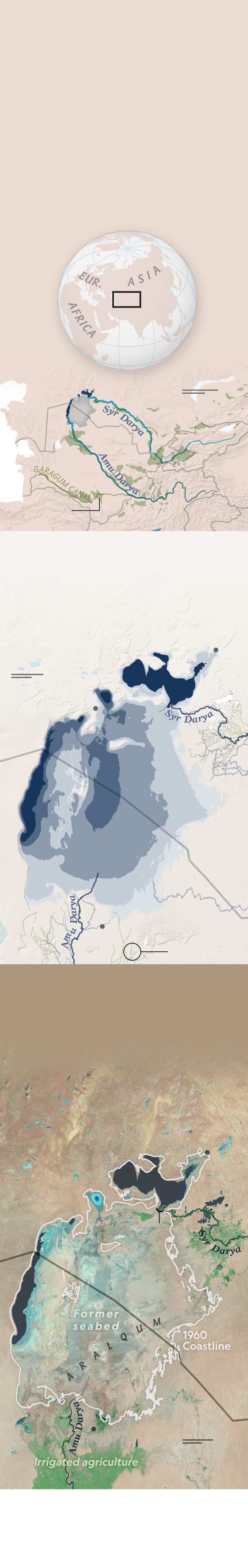
Fading of a Sea
Once the world’s fourth largest lake, the Aral Sea
has diminished to a fraction of its former grandeur.
By the 1960s, the Soviet practice of diverting water
from the Syr Darya and Amu Darya rivers to irrigate
cropland began to show an impact. For six decades,
evaporation has continued to reduce the lake year
after year. Salts are concentrated in remaining
waters and exposed lake beds, making the region
increasingly inhospitable.
MAP
AREA
N. Aral Sea
Irrigated cropland
KAZAKHSTAN
S. Aral Sea
Aral Sea,
1960
Caspian
Sea
KYRGYZSTAN
Tashkent
UZBEKISTAN
CHINA
TURKMENISTAN
TAJIKISTAN
Ashgabat
IRAN
PAKISTAN
AFGHANISTAN
INDIA
Evaporating away
In the south, the coast has receded to the
far western part of the basin. In the north,
where water is collected behind a dam,
lake levels remain stable.
Aral
Aqespe
Irrigation
canals
Aral Sea coverage
in square miles
Aral Sea coverage
in square miles
2025
1960: 23,840
1960: 23,840
1975: 21,035
1975: 21,035
Qulandy
1990: 12,860
1990: 12,860
Qazaly
2005: 4,540
2005: 4,540
2025: 1,960 sq mi
2025: 1,960 sq mi
2005
1990
1975
KAZAKHSTAN
UZBEKISTAN
1960
2025
Muynoq
Qozoqdaryo
25
mi
25
km
What remains of the Aral Sea
This colorized infrared view enhances the difference between the
waters and the former lake bed now known as the Aralqum,
a polluted desert full of salt, pesticides, and fertilizers deposited as
the water receded. Winds stir up the toxic mix, blowing it westward
into Eastern Europe.
Aral
25
mi
North Aral Sea
25
km
Tushchyba
Lake
Wetland
Kokaral
Dam
1960
Coastline
KAZAKHSTAN
UZBEKISTAN
South
Aral
Sea
1960
Coastline
Muynoq
Wetland
Qozoqdaryo
Matthew W. Chwastyk, NGM Staff
Sources: World Meteorological Organization; UN Food and Agriculture Organization;
Openstreetmap; USGS; NASA/JPL; ESA; Merit DEM
Fading of a Sea
Once the world’s fourth largest lake,
the Aral Sea has diminished to a
fraction of its former grandeur. By the
1960s, the Soviet practice of diverting
water from the Syr Darya and Amu
Darya rivers to irrigate cropland began
to show an impact. For six decades,
evaporation has continued to reduce
the lake year after year. Salts are
concentrated in remaining waters and
exposed lake beds, making the region
increasingly inhospitable.
MAP
AREA
Aral Sea,
1960
N. Aral Sea
S. Aral Sea
KAZAKH.
KYRG.
UZB.
Caspian
Sea
TURKM.
CHINA
TAJ.
Irrigated
cropland
PAK.
AFG.
INDIA
Evaporating away
In the south, the coast has receded to
the far western part of the basin. In
the north where water is collected
behind a dam, lake levels
remain stable.
Aral
25
mi
25
km
2025
Qulandy
1990
2005
1975
KAZAKHSTAN
UZBEKISTAN
2025
1960
Qozoqdaryo
Irrigation
canals
What remains of the Aral Sea
This colorized infrared view enhances
the difference between the waters
and the former lake bed now known
as the Aralqum, a polluted desert full
of salt, pesticides, and fertilizers
deposited as the water receded.
Winds stir up the toxic mix, blowing it
westward into Eastern Europe.
Aral
N. Aral Sea
Tushchyba
Lake
Kokaral
Dam
KAZAKHSTAN
UZBEKISTAN
South
Aral
Sea
1960
Coastline
Qozoqdaryo
25
mi
25
km
Matthew W. Chwastyk, NGM Staff
Sources: World Meteorological
Organization; UN Food and Agriculture
Organization; Openstreetmap; USGS;
NASA/JPL; ESA; Merit DEM