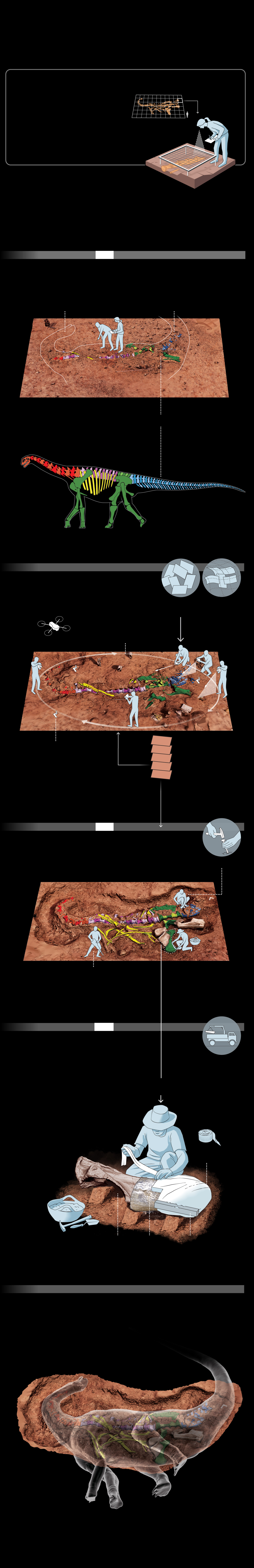
MAPPING DINOS IN THE DESERT
For decades, the standard means of documenting a
dig site required patient field drawing and laborious
measurement. Now photogrammetry can accomplish
in minutes what otherwise takes days (and in 3D).
TRADITIONAL SITE MAPPING
MAPPING FRAME
3-foot grid
Paleontologists set up a grid to
plot fossil locations, measuring
and drawing by hand. But an
artist’s angle of view is limited,
and the method is time-
consuming and less detailed.
Distorted perspective
DIGITAL SITE MODELING
In Niger, Sereno and his team relied on tools that stitch
together photos to make spatially accurate 3D site models.
Less manual mapping meant more time for digging.
Day 1
1. DISCOVERY
The team found fossils on a prior trip to the Irhazer Plain,
preserving them from erosion with a plaster cap. In 2022,
they returned to excavate the mysterious animals.
HEAD
TAIL
SITE MODELS
FROM NIGER
EXPEDITION
COLOR KEY FOR FOSSILIZED BONES
Head and neck
Back
Tail
Hips and legs
Ribs
2. MAPPING WITH PHOTOS
Hundreds of photos from drones and handheld
cameras recorded the excavation’s progress.
Anchor points common to the images allowed
photogrammetry software to connect them.
Individual
images
Overlapping
MULTIPLE
CAMERA
ANGLES
Drone
3 or 4 points
of reference
Middle stage
Final stage
Day 12
3. EXCAVATION
The team carefully brushed and chipped away
rock and dirt surrounding fossils, using hand and
power tools. Fossil measurements and positioning
data could be gleaned from the digital models.
Hand tools
Lightweight
electric
jackhammer
Day 20
4. FOSSIL PREPARATION
Fossils freed from most of their surrounding
rock were wrapped in casts, called jackets.
Wooden braces helped protect brittle or
fractured fossils during transport.
Crane to lift bones
PREPARING THE BONES
FOR TRANSPORT
Strips of burlap
Plaster
Space below to allow wrapping
Aluminum foil
Wooden brace
5. FOSSIL MODELING
Photogrammetry also let the team make 3D models
of individual fossils for virtual study—and to envision
how an animal might have looked.
NEW SAUROPOD
Heavily built, short-necked plant-eater, estimated to be 40 feet long
Graphic: Fernando G. Baptista, Patricia Healy, and Lucas Petrin, NGM Staff.
3D renders by Daniel Vidal. Sources: Paul Sereno, University of Chicago;
Daniel Vidal, UNED & University of Chicago

MAPPING DINOS
IN THE DESERT
For decades, the standard means of
documenting a dig site required
patient field drawing and laborious
measurement. Now photogramm-
etry can accomplish in minutes what
otherwise takes days (and in 3D).
DIGITAL SITE MODELING
In Niger, Sereno and his team relied
on tools that stitch together photos
to make spatially accurate 3D site
models. Less manual mapping
meant more time for digging.
TRADITIONAL SITE MAPPING
Paleontologists set up a grid to
plot fossil locations, measuring
and drawing by hand. But an
artist’s angle of view is limited,
and the method is time-
consuming and less detailed.
MAPPING FRAME
3-foot grid
Distorted perspective
Day 1
1. DISCOVERY
The team found fossils on a prior trip
to the Irhazer Plain, preserving them
from erosion with a plaster cap.
In 2022, they returned to excavate
the mysterious animals.
HEAD
TAIL
SITE MODELS
FROM NIGER
EXPEDITION
COLOR KEY FOR FOSSILIZED BONES
Head and neck
Back
Tail
Ribs
Hips and legs
2. MAPPING WITH PHOTOS
Hundreds of photos from drones
and handheld cameras recorded the
excavation’s progress. Anchor points
common to the images allowed
photogrammetry software
to connect them.
Drone
Individual images
Overlapping
MULTIPLE
CAMERA ANGLES
3 or 4 points
of reference
Middle stage
Final stage
Day 12
3. EXCAVATION
The team carefully brushed and
chipped away rock and dirt surroun-
ding fossils, using hand andpower
tools. Fossil measurements and
positioningdata could be gleaned
from the digital models.
Hand tools
Lightweight
electric
jackhammer
Day 20
4. FOSSIL PREPARATION
Fossils freed from most of their
surroundingrock were wrapped in
casts, called jackets.Wooden braces
helped protect brittle orfractured
fossils during transport.
PREPARING THE BONES FOR TRANSPORT
Crane to lift bones
Strips of burlap
Plaster
Space below to allow wrapping
Aluminum foil
Wooden brace
5. FOSSIL MODELING
Photogrammetry also let the team
make 3D models of individual fossils
for virtual study—and to envision
how an animal might have looked.
NEW SAUROPOD
Heavily built, short-necked plant-eater, estimated to be 40 feet long
Graphic: Fernando G. Baptista,
Patricia Healy, and Lucas Petrin,
NGM Staff. 3D renders by Daniel Vidal.
Sources: Paul Sereno, University of
Chicago; Daniel Vidal, UNED & University
of Chicago