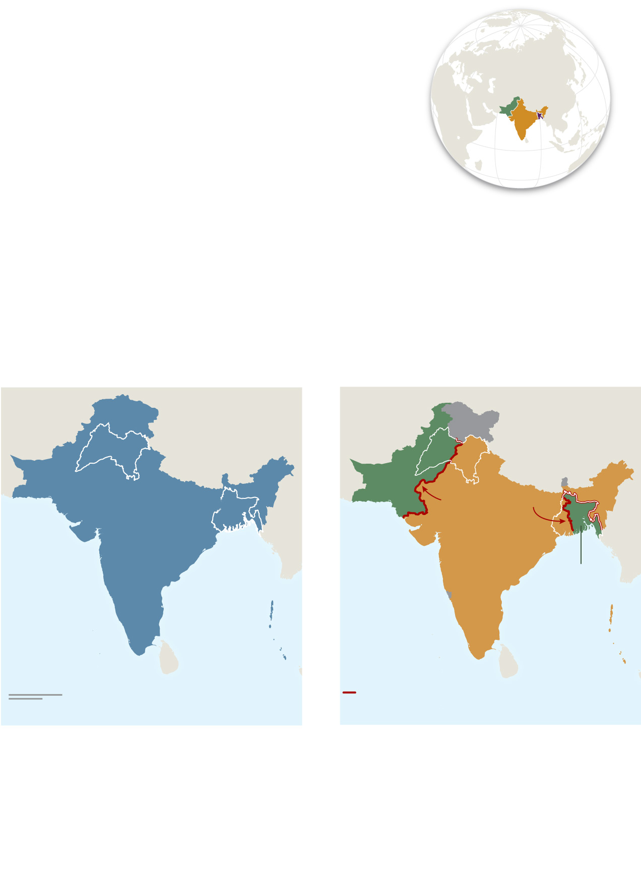
How the British split India
With the end of British colonial rule in 1947, the Indian
subcontinent was divided into two nations, majority-
Hindu India and majority-Muslim Pakistan. The hastily
planned transition led to one of the largest refugee
crises in history.
Asia
India
Pakistan
BANGLADESH
After Partition
Colonial rule
Dividing the country by religion
proved difficult, especially in the
provinces of Punjab and Bengal,
which had near-equal Hindu and
Muslim populations. The resulting
creation of a noncontiguous Pakistan
forced millions of Hindus and
Muslims to relocate.
Before Partition, Hindus accounted
for nearly 70 percent of British
India’s population while Muslims
made up only a quarter. Although
most Muslim-majority communities
were in the north, religious groups
were dispersed throughout
the country.
Jammu
and
KASHMIR
PUnjAB
PAKISTAN
Radcliffe Line
British
India
BENGAL
India
Bay of
Bengal
PAKISTAN
(East Pakistan, 1955;
Bangladesh 1971)
Indian
Ocean
Indian
Ocean
400 mi
Radcliffe Line, partition
drawn by British officials
400 km
Areas of contention
In the north, the Radcliffe Line stopped at Jammu and Kashmir, a princely state
that chose to remain independent after Partition. The border is still contested.
Rosemary Wardley, NG Staff.
Source: The CShapes 2.0 Dataset, Guy Schvitz and others, Journal of Conflict
Resolution, 2022
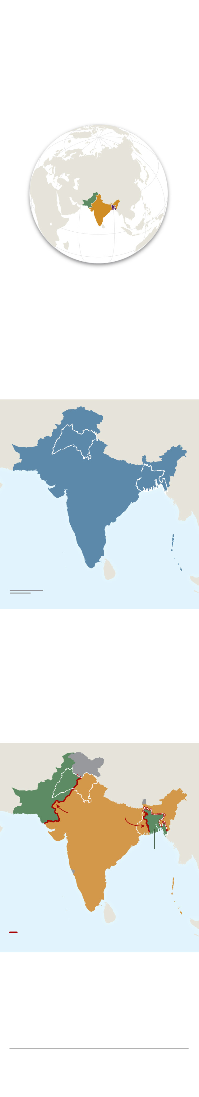
How the British split India
With the end of British colonial rule in
1947, the Indian subcontinent was
divided into two nations, majority-
Hindu India and majority-Muslim
Pakistan. The hastily planned transition
led to one of the largest refugee
crises in history.
Asia
India
Pakistan
BANGLADESH
Colonial rule
Before Partition, Hindus accounted
for nearly 70 percent of British
India’s population while Muslims
made up only a quarter. Although
most Muslim-majority communities
were in the north, religious groups
were dispersed throughout
the country.
PUnjAB
British
India
BENGAL
Bay of
Bengal
Indian
Ocean
400 mi
400 km
After Partition
Dividing the country by religion
proved difficult, especially in the
provinces of Punjab and Bengal,
which had near-equal Hindu and
Muslim populations. The resulting
creation of a noncontiguous Pakistan
forced millions of Hindus and
Muslims to relocate.
Jammu
and
KASHMIR
PAKISTAN
Radcliffe Line
India
PAKISTAN
(East Pakistan, 1955;
Bangladesh 1971)
Indian
Ocean
Radcliffe Line, partition
drawn by British officials
Areas of contention
In the north, the Radcliffe Line
stopped at Jammu and Kashmir, a
princely state that chose to remain
independent after Partition. The
border is still contested.
Rosemary Wardley, NG Staff.
Source: The CShapes 2.0 Dataset, Guy
Schvitz and others, Journal of Conflict
Resolution, 2022